Cung cấp cho bạn đầy đủ từ vựng trắc địa cùng hình ảnh minh họa và các bài đọc có kèm theo bài dịch. Sau mỗi lesson sẽ là bài tập tóm lại kiến thức
1.1. SURVEYING: TRẮC ĐỊA
1. Từ mới:
Define: [di’fain]: v: định nghĩa.
Measurement: [‘məʒəmənt]: n: sự đo lường, phép đo
Relative: [‘relətiv]: adj: liên quan đến, tương đối
Position: [pə’zi∫n]: n: vị trí; lập trường, quan điểm
Man made: do con người tạo ra, nhân tạo.
Feature: [‘fi:t∫ə]: n: điểm đặc trưng
Surface: [‘sə:fis]: n: bề mặt
Presentation: [,prezen’tei∫n]: n: sự trình bày
Graphically: [‘græfikəli]: adv: bằng đồ thị
Numerically: [nju:’merikəli]: bằng kĩ thuật số
Distance: [‘distəns]: n: khoảng cách
Angle: [‘æηgl]: n: góc
Direction: [di’rek∫n]: n: hướng
Location: [lou’kei∫n]: n: vị trí
Elevation: [,eli’vei∫n]: độ cao
Area: [‘eəriə]: n: vùng; diện tích
Volume: [‘vɔlju:m]: n: thể tích
Thus: [đʌs]: adv: theo cách đó, do vậy
Determine [di’tә:min]: v: xác định, định rõ
Portray: [pɔ:’trei]: v: miêu tả
Construction: [kən’strʌk∫n]: n: sự xây dựng
Profile: [‘proufail]: n: tiểu sử, mặt cắt nghiêng, bản vẽ
Cross-section [‘krɔs’sek∫n]: n: mặt cắt ngang
Diagram: [‘daiəgræm]: n: biểu đồ
Process [‘prouses]: n: quy trình / v: gia công, xử lí
Divide: [di’vaid]: v: chia ra
Field-work: [‘fi:ld,wə:kə]: n: công việc ngoại nghiệp
Office-work: [‘ɔfis,wə:kə]: n: công tác nội nghiệp
Necessary [‘nesisəri]: adj: cần thiết, thiết yếu
Purpose: [‘pə:pəs]: n: mục đích / v: có mục đích
2. Bài đọc:
Surveying may be defined as the art of making measurement of the relative positions of natural and manmade features on the Earth’s surface, and the presentation of this information either graphically or numerically.
Distances, angles, directions, locations, elevations, areas and volumes are thus determined from data of the survey. Also, much of the information of the survey is portrayed graphically or numerically by the construction of maps, profiles, cross-sections and diagrams.
Thus, the process of surveying may be divided info the field-work of talking measurements and the office-work of computing and drawing necessary to the purpose of the survey.
3. Dịch:
Công tác đo đạc được định nghĩa là một kỹ thuật tạo ra các trị đo vị trí tương hỗ của các điểm đặc trưng tự nhiên và nhân tạo trên bề mặt Trái đất, và sự biểu diễn những thông tin này thì bằng cả đồ họa và dạng số.
Khoảng cách, góc, hướng, vị trí, độ cao, diện tích và thể tích có thể được xác định từ các dữ liệu đo đạc. Hầu hết các thông tin của việc đo đạc được thể hiện dưới dạng đồ họa hoặc dạng số bằng cách thành lập bản đồ, bản vẽ, mặt cắt, biểu đồ.
Theo đó, quá trình đo đạc có thể được phân ra công tác ngoại nghiệp tạo ra trị đo và công việc nội nghiệp tính toán và vẽ các yếu tố cần thiết cho mục đích đo đạc.
1.2. USES OF SURVEYS: Ứng dụng của trắc địa
1. Từ mới:
Establish: [is’tæbli∫]: v: thành lập, thiết lập
Boundary: [‘baundəri]: n: biên giới
Project [‘prədʒekt]: n: dự án
Magnitude: [‘mægnitju:d]: độ lớn
Base on (upon) sth: dựa trên một cái j
To greater or lesser: ít hay nhiều
Aside [ə’said]: adv: sang một bên / pre: ngoài ra, trừ ra
Assistance [ə’sistəns]: n: sự giúp đỡ
Conception [kən’sep∫n]: n: quan niệm
Execution [,eksi’kju:∫n]: n: sự thi hành, sự thực hiện
Conduct [‘kɔndʌkt]: v: hướng dẫn
Variety [və’raiəti]: n: đa dạng
Charting: [t∫ɑ:t]: n: biểu đồ / v: vẽ biểu đồ
Charting of coast lines: bản đồ đường bờ biển
Navigable: [‘nævigəbl]: adj: có thể đi lại được
NAVSTAR GPS: Navigation Satellite Timing And Ranging Global Positioning System
Stream: [stri:m]: n: suối
Precise [pri’sais]: adj: chính xác
Definite: [‘definit]: adj: xác định, định rõ
Reference [‘refərəns]: n: sự tham khảo, sự chỉ dẫn
Throughout: [θru:’aut]: pre: trải dài / adv: khắp nơi
Valuable: [‘væljuəbl]: adj: có giá trị
Mineral: [‘minərəl]: adj: thuộc về khoáng sản / n: khoáng sản
Deposit: [di’pɔzit]: n: mỏ (khoáng sản)
Concerning: [kən’sə:niη]: pre: liên quan đến
Magnetism: [‘mægnitizm]: n: từ tính, trường trọng lực
Scattered: [‘skætəd]: adj: rải rác
Portion: [‘pɔ:∫n]: n: phân chia
Particularly: [pə,tikju’lærəli]: adv: một cách đặc biệt
Regard: [ri’gɑ:d]: n, v: quan tâm, liên quan đến
Obtain: [əb’tein]: v: thu được, giành được
Property: [‘prɔpəti]: n: sở hữu; của cải; thuộc tính, đặc tính
2. Bài đọc:
The earliest surveys known were for the purpose of establishing the boundaries of land, and such surveys are still the important work of many surveyors.
Every construction project of any magnitude is based to a greater of lesser degree upon measurements taken during the process of a survey and is constructed about lines and points established by the surveyor. Aside from land surveys, surveys are of assistance in the conception, design, and execution of engineering works.
Surveys are conducted for a variety of purposes, such as the fixing of national and state boundaries, the charting of coast lines, and navigable streams and lakes, the precise location of definite reference points throughout the country, the collection of valuable facts concerning the Earth’s magnetism at widely scattered stations, the mapping of certain portions of the country, particularly in the location of valuable mineral deposits, est.
Summing up, surveys are divided into three classes:
– Those for the primary purpose of establishing the boundaries of landed properties,
– Those forming the basic of a study for or necessary to the construction of public and private works and
– Those of large extent and high precision conducted by the government. There is no hard and fast line of determination between surveys of one class and those of another, as regards of methods, employed, results obtained, or use of the data of the survey.
3. Dịch:
Việc đo đạc sớm nhất được biết đến là nhằm phục vụ cho mục đích thiết lập ranh giới đất đai, và những công tác ấy vẫn là công việc quan trọng của những người trắc địa.
Các dự án xây dựng ở bất kỳ mức độ nào, dù ít hay nhiều đều dựa trên việc tạo ra trị đo trong quá trình đo đạc và được xây dựng theo các đường hoặc điểm được lập bởi những người đo đạc. Ngoài đo đạc đất đai, trắc địa còn giúp lập các ý tưởng, thiết kế, và thực hiện các công trình xây dựng.
Việc đo đạc được tiến hành cho nhiều mục đích, như việc xác định ranh giới quốc gia và khu vực, lập bản đồ đường bờ biển và những dòng suối và hồ nước có thể đi lại được, vị trí chính xác các điểm trải dài trên khắp cả nước, việc thu thập các dữ kiện có giá trị liên quan tới trường trọng lực của Trái đất tại các trạm phân bố rộng khắp, thành lập bản đồ từng khu vực của đất nước, đặc biệt ở vị trí các mỏ khoáng sản có giá trị, v.v
Tóm lại, công tác đo đạc được chia thành ba phần chính:
– phục vụ mục đích chính là phân biệt ranh giới, đặc tính của các thửa đất.
– Tạo ra các nền tảng cho việc nghiên cứu hoặc sự cần thiết cho xây dựng các công trình công cộng và cá nhân
– Đo đạc trong phạm vi lớn và độ chính xác cao được tiến hành bởi chính phủ.
Không có ranh giới rõ ràng giữa việc đo đạc trong các lớp và từng lớp một, mà phương pháp, công việc, kết quả thu nhận, hoặc sử dụng các dữ liệu của việc đo đạc .
1.3. PLANE SURVEYING: TRẮC ĐỊA ĐỊA HÌNH
1. Từ mới:
Considerd: [kən’sidə]: v: xem xét đến
Considered as = taken into account as = taken into consideration as
Spheroidal: [sfiə’rɔidl]: adj: có dạng hình cầu
Shape [∫eip]: hình dạng, khuôn mẫu / v: định hướng
Neglect: [ni’glekt]: n: sự sao lãng, không chú ý / v: sao lãng, không chú ý
Horizontal: [,hɔri’zɔntl]: adj: thuộc chân trời; nằm ngang, ngang / n: đường nằm ngang
Mathematical: [,mæθə’mætikl]: adj: (thuộc) toán học
Straight: [streit]: adj: thẳng
Plumb: [plʌm]: n: quả dọi
Within: [wi’đin]: pre: trong vòng, trong khoảng thời gian
Parallel: [‘pærəlel]: adj: song song
Polygon: [‘pɔligən]: n: đa giác
Level line: đường chuẩn
Canal: [kə’næl]: v: kênh
Except: [ik’sept]: v: trừ ra, loại ra
2. Bài đọc:
That type of surveying in which the mean surface of the Earth is considered as a plane, or in which its spheroidal shape is neglected, is generally defined as plane surveying. With regard to horizontal distances and directions, a level line is considered as mathematically straight, the direction of the plumb line at any point within the limits of the survey is considered as parallel to the direction of the plumb line at any other point, and the angles of polygons are considered as the plane angles.
Surveys for the location and construction to highways, railroads, canals, and, in general, the surveys necessary for the works of man are plane surveys, as are also the surveys made for the purpose of establishing boundaries, except state and national.
3. Dịch:
Loại đo đạc mà trong đó coi bề mặt trung bình của trái đất như 1 mặt phẳng, hoặc hình dạng mặt cầu bị bỏ qua, thường được định nghĩa là trắc địa phổ thông. Đối với khoảng cách ngang và hướng, một đường chuẩn được coi như 1 đường thẳng toán học, hướng đường dây dọi tại bất kỳ một điểm với giới hạn đo đạc thì được coi là song song với đường dậy dọi tại bất kỳ một điểm khác, và góc của đa giác được coi là góc phẳng.
Việc đo đạc để xác định vị trí và xây dựng các đường cao tốc, đường sắt, kênh mương và, nói chung, việc đo đạc cần thiết cho hoạt động của con người thì được gọi là trắc địa phổ thông, cũng như việc đo đạc được thực hiện cho mục đích phân biệt ranh giới, ngoại trừ ranh giới khu vực và quốc gia.
1.4. GEODETIC SURVEYING: TRẮC ĐỊA CAO CẤP
1. Từ mới:
Geodetic [,dʒi:ou’detik]: Geodetic Surveying: Trắc Địa Cao cấp
Branch: [brɑ:nt∫]: n: nhánh, chi nhánh / v: phân nhánh
Distinguish [dis’tiηgwi∫]: v: phân biệt, chỉ ra sự khác biệt
Technique: [tek’ni:k]: n : kĩ thuật, công nghệ
Involve [in’vɔlv]: v: bao gồm
Curvature [‘kə:vət∫ə]: n: độ cong, sự uốn cong
Explain [iks’plein]: v: giảng giải, giải thích
Framework [‘freimwə:k]: n: khung, sườn; lưới cơ sở
Angular: [‘æηgjulə]: adj: (thuộc)góc, có góc cạnh
Task [tɑ:sk]: n: nhiệm vụ, công việc / v: giao nhiệm vụ
Include [in’klu:d]: v: bao gồm
Positional [pə’zi∫ənəl]: (thuộc) vị trí
Global positioning system: GPS: hệ thống định vị toàn cầu
Transmission [trænz’mi∫n]: n: sự truyền, sự phát
Satellite [‘sætəlait]: n: vệ tinh
Co-ordinate [kou’ɔ:dineit]: n: tọa độ
Accuracy [‘ækjurəsi]: n: độ chính xác
Hence [hens]: adv: kể từ đấy; do đó
2. Bài đọc:
Geodetic surveying is actually branch of surveying distinguished both by use and technique. In geodetic surveying large areas of the Earth’s surface are involved and the curvature of the Earth must be taken into account. As will be explained shortly, framework of angular and distance measurements between points are necessary to control all surveys and when surveying large areas, such as a whole country, the measurements must be taken to the highest possible standard. Modern methods for this task include global positioning system which use transmissions from satellites to obtain the three dimensional co-ordinates of any point on the Earth’s surface to a high degree of accuracy. The study of the size and shape of the Earth and its gravity field is known as geodesy, hence the name of this type of surveying.
3. Dịch:
Trắc địa cao cấp thực tế là một nhánh của trắc địa, được phân biệt ở ứng dụng và kỹ thuật. Trong trắc địa cao cấp, các bề mặt rộng lớn trên trái đất có liên quan và độ cong trái đất phải được tính đến. Giải thích một cách ngắn gọn, lưới khống chế đo góc và các trị đo cạnh giữa các điểm là cần thiết cho việc tiến hành công tác đo đạc và đo đạc trong phạm vi rộng lớn, như là một quốc gia, thì các trị đo phải được đưa về tiêu chuẩn độ chính xác cao nhất có thể. Phương pháp hiện đại cho công việc này bao gồm hệ thống định vị toàn cầu trong đó sự truyền tín hiệu từ vệ tinh nhân tạo để thu nhận được tọa độ ba chiều của bất kì điểm nào trên mặt đất với độ chính xác cao. Việc nghiên cứu hình dạng và kích thước trái đất và trường trọng lực của nó được biết đến là trắc địa cao cấp, do đó loại hình này cũng gọi là trắc địa.
EXERCISE:
1. How can surveying be defined?
Surveying may be defined as the art of making measurement of the relative positions of natural and manmade features on the Earth’s surface, and the presentation of this information either graphically or numerically.
2. How is much of the information of the survey portrayed?
Much of the information of the survey is portrayed graphically or numerically by the construction of maps, profiles, cross-section, and diagrams.
3. How many the process of surveying be divided?
The process of surveying may be divided info the field-work of talking measurements and the office-work of computing and drawing necessary to the purpose of the survey.
4. What was the purpose of the earliest surveys?
The earliest surveys known were for the purpose of establishing the boundaries of land.
5. Why must every construction project be based on surveys?
Because surveys are assistance in the conception, design, and execution of engineering works.
6. What can you say about the level line, the direction of a plumb line and the angles of polygons in plane surveying?
In plane surveying, a level line is considered as mathematically straight, the direction of the plumb line at any point within the limits of the survey is considered as parallel to the direction of the plumb line at any other point, and the angles of polygons are considered as the plane angles.
7. Where are plan surveys employed?
Plane surveys are employed for the location and construction to highways, railroads, canals, and, in general, the surveys necessary for the works of man are plane surveys, as are also the surveys made for the purpose of establishing boundaries, except state and national.
8. In plane surveying, how is the Earth’s surface assumed to be? Why?
In plane surveying, the Earth’s surface assumed to be a plane, because it’s conducted in a small area of the Earth’s surface.
9. What must be taken into account in geodesy surveying? Why?
In geodetic surveying, the curvature of the Earth must be taken into account because large areas of the Earth’s surface are involved
10. What do modern methods in geodesy surveying include?
Modern method for this task include global positional system which us transmissions from satellites to obtain the three dimensional co-ordinates of any point on the Earth’s surface to a high degree of accuracy.
Lesson 2: TRIANGULATION
2.1. INTRODUCTION:
1. Từ mới:
Triangulation: [trai,æηgju’lei∫n]: n: lưới tam giác
Triangle: [‘traiæηgl]: n: hình tam giác
Extensive: [iks’tensiv]: adj: rộng ng về diện tích; kéo dài ra xa
Means: [mi:nz]: n: phương tiện, cách thức
Topographic: [,tɔpə’græfik]: adj: Cách viết khác: topographical [,tɔpə’græfikl]: (thuộc) phép đo về địa hình, thuộc về địa hình
Similar: [‘similə]: adj: giống nhau, như nhau, tương tự, cùng loại, cùng hình dáng
Adjacent: [ə’dʒeisnt]: adj: gần kề, kế liền, sát ngay
Vertex (pl. vertices, vertexes): [‘və:teks]: n: đỉnh , chỏm, chóp, ngọn, điểm cao nhất
Avoid: [ə’vɔid]: v: tránh, tránh xa, ngăn ngừa
Absolute: [‘æbsəlu:t]: adj: tuyệt đối, hoàn toàn; thuần tuý, nguyên chất
Unavoidable: [,ʌnə’vɔidəbl]: adj: không thể tránh được; tất yếu
Desirable: [di’zaiərəbl]: adj: mong muốn, ao ước
Arrangement: [ə’reindʒmənt]: n: sự sắp xếp, sự sắp đặt, cái được sắp xếp, cái được sắp đặt
Afford: [ə’fɔ:d]: v: có thể, có đủ sức, có đủ khả năng, có đủu điều kiện / tạo cho, cấp cho, ban cho
Geometrical: [dʒiə’metrikəl] / Figure: [‘figə]
Geometrical Figure: đồ hình
Theoretical: [,θiə’retikl]: adj: (thuộc) lý thuyết; có tính chất lý thuyết
Proportional: [prə’pɔ:∫ənl]: adj: (proportional to something) tương ứng về cỡ, số lượng hoặc mức độ (với cái gì); có tỷ lệ đúng; cân xứng
Opposite: [‘ɔpəzit]: adj: (opposite to somebody / something) đối nhau, ngược nhau, ngược lại
Condition: [kən’di∫n]: n: điều kiện
Adjust: [ə’dʒʌst]: v: đặt lại cho đúng vị trí hoặc trật tự; điều chỉnh
Adjusting: bình sai
Secure: [si’kjuə]: adj: (secure about something) không có cảmm giác lo âu, nghi ngờ; an tâm; yên tâm; bảo đảm
Probable: [‘prɔbəbl]: adj: có thể xảy ra hoặc có thể là như thế; chắc hẳn
Quantity: [‘kwɔntəti]: n: lượng, số lượng, khối lượng
Procedure: [prə’si:dʒə]: n: thủ tục
Permit: [‘pə:mit]: n: giấy phép
Application: [,æpli’kei∫n]: n: sự gắn vào, sự áp vào / sự áp dụng
Therefore: [‘đeəfɔ:]: adv: bởi vậy, cho nên, vì thế, vậy thì
Customary: [‘kʌstəməri]: adj: theo phong tục thông thường
Rather: [‘rɑ:đə]: adv: đúng hơn, hơn là
Require: [ri’kwaiə]: v: phụ thuộc vào ai/cái gì để đạt được kết quả; cần đến
Characteristic: [,kæriktə’ristik]: adj: (characteristic of sb/sth) cấu thành bộ phận của tính cách một người; tiêu biểu
Additional: [ə’di∫ənl]: adj: cộngng thêm; thêm vào
Redundant: [ri’dʌndənt]: adj: thừa, dư
Additional (Redundant): trị đo thừa
Improve: [im’pru:v]: v: cải tiến, cải thiện, cải tạo
2. Bài đọc:
Triangulation is employed extensively as a means of control for topographic and similar surveys. A triangulation system consists of a series of triangles in which one or more sides of each triangle are also sides of adjacent triangles. The lines of a triangulation system form a network tying together the points or stations at which the angles are measured. The vertices of the triangles are the triangulation stations.
By the use of the triangulation method, the necessity of measuring the length of every line is avoided. If it was possible to measure one side and all the angles in a triangulation system with absolute precision, no further linear measurements would be necessary. Unavoidable errors in the field measurements, however, make it desirable the lengths of two or more lines in each system be measured as a means of checking the computed distances. The lines whose lengths are measured are called based lines.
The arrangement of the triangles in most system affords many different geometrical figures for each of which the theoretical value of the sum of the included angles is known. Also, the sum of the angles about any station should equal 3600, and in any triangle the lengths of the sides should be proportional to the sines of the angles opposite. There known conditions serve as a measure of the precision of the angle measurements and as a means of adjusting the errors so as to secure the most probable values of the measured quantities.
It is not necessary that every angle in a triangulation system be measured; the third can be readily computed. This procedure, however, does not permit the application of the known conditions as a measure of the precision of the measurements, or as a means of adjusting the errors. Therefore, it is customary to measure all angles. If all angles were measured, rather more information would be available than required, but it is characteristic of these surveys that additional (or redundant) measurements are taken both to check the data and by adjustments to improve the precision of the final results.
3. Dịch:
Lưới tam giác được thực hiện rộng rãi như một phương tiện để khống chế địa hình và công tác đo đạc tương tự. Một mạng lưới tam giác gồm có 1 chuỗi tam giác thì ở đó, một hay nhiều cạnh của tam giác cũng là cạnh của các tam giác liền kề. Các cạnh của một hệ thống lưới tam giác tạo thành một mạng lưới liên kết với nhau ở các điểm và trạm máy, mà ở đó các góc đều được đo. Các đỉnh của hình tam giác là các trạm máy của lưới tam giác.
Bằng việc sử dụng phương pháp lưới tam giác, không cần thiết phải đo chiều dài của tất cả các cạnh. Nếu có thể đo 1 cạnh và tất cả các góc trong lưới tam giác với độ chính xác tuyệt đối, thì việc đo thêm chiều dài các cạnh là không cần thiết. Việc đo đạc ngoài thực địa không thể tránh khỏi sai số, tuy nhiên, làm cho nó thỏa mãn chiều dài của 2 hay nhiều cạnh hơn trong mỗi hệ thống được đo đạc là phương pháp để kiểm tra độ dài tính toán. Những cạnh có chiều dài được đo thì được gọi là cạnh đáy.
Sự sắp xếp của các tam giác trong hầu hết các mạng lưới có thể tạo ra sự khác nhau rất nhiều về đồ hình, với mỗi tam giác trong đồ hình thì tổng lý thuyết của tất cả các góc bên trong là cố định. Cũng như vậy, tổng các góc xung quanh bất kì trạm nào phải bằng 360 độ, và trong mỗi tam giác, chiều dài các cạnh phải tỉ lệ thuận với sin của góc đối diện. Việc thỏa mãn các điều kiện đã biết đó phục vụ đánh giá độ chính xác đo góc và như là 1 phương pháp bình sai các sai số để cho đạt được kết quả xác suất của nhiều trị đo.
Không cần thiết phải đo tất cả các góc trong mạng lưới tam giác, góc thứ 3 có thể được tính toán ra một cách dễ dàng. Thủ tục trên, tuy nhiên, không thể cho phép áp dụng các điều kiện đã biết trong việc tính toán độ chính xác của các trị đo, hoặc như một phương pháp để bình sai các sai số. Vì thế, người ta thường đo tất cả các góc. Nếu tất cả các góc đều được đo, ta sẽ biết nhiều thông tin hơn yêu cầu, nhưng nó là đặc trưng cho trắc địa, cái mà các trị đo thừa đều được thực hiện để kiểm tra các trị đo và bình sai để tăng độ chính xác của kết quả cuối cùng.
2.2. BASE NETS:
1. Từ mới:
Proper [‘prɔpə]: adj: thích hợp, thích đáng.
Obviously [‘ɒbviəsli]: adj: rõ ràng; hiển nhiên
Economical: [,i:kə’nɔmikəl]: adj: tiết kiệm, kinh tế
Average: [‘ævəridʒ]: n; adj; v: trung bình
Attention: [ə’ten∫n]: n: sự chú ý
Excellent: [‘eksələnt]: adj: xuất sắc, ưu tú
Expansion: [iks’pæn∫n]: n: sự mở rộng, sự bành trướng, sự phát triển.
Satisfactory [,sætis’fæktəri]: adj: vừa ý; thoả đáng
Lay out [‘leiaut]: n: cách bố trí, cách trình bày; sự sắp đặt
Scheme: [ski:m]: n: sự sắp xếp theo hệ thống; sự phối hợp / v: mưu đồ, bố trí
Discuss: [dis’kʌs]: v: thảo luận
EDM: Electronic Distance Measurement: đo chiều dài điện tử.
Instrument: [‘instrumənt]: n: dụng cụ; công cụ
Aid: [eid]: n: sự giúp đỡ, sự cứu giúp, sự viện trợ/phương tiện trợ giúp
Restrict: [ri’strikt]: v: hạn chế, giới hạn
Brace: [breis]: n:
Quadrilateral: [,kwɔdri’lætərəl]: adj: có bốn cạnh, tứ giác/ n: hình tứ giác
Thereby: [,đeə’bai]: adv: bằng cách ấy, theo cách ấy; do đó
Trilateration: [trailætə’rei∫n]: n: phép đo ba cạnh tam giác
Framework: [‘freimwə:k]: n: lưới cơ sở
Trilateration framework: lưới tam giác đo cạnh
Convention: [kən’ven∫n]: n: hội nghị, sự triệu tập/ quy ước
2. Bài đọc:
In a system of triangulation, long sides (within proper limits) are obviously more economical than short ones. It is difficult and expensive to measure long base lines; hence, in practice, the base lines are usually much shorter than the average length of the triangle sides. This condition necessitates the most careful attentions to the location of the base lines and the immediately adjacent stations. The figure formed by this group of stations is called the base net and is formed so as to permit economical lengths of triangles sides to be used with a minimum less in the precision of the measured base line.
The figure 2.1.a is an example of an excellent base net affording quick and accurate expansion of the base line to the longer sides of the system. The form of base net show in the figure 2.1.b is satisfactory if it can be so laid out as to avoid the small angular.
Figure 2.1: Base Nets
Scheme of the simple design discussed so far are extremely useful when EDM instruments and calculating aids are not available because distance measurement and calculation can be kept to a minimum. However, when EDM equipment is available then more than one distance would be measured and the layout of the control scheme would not be restricted to braced quadrilaterals and centre-point polygons. In fact, we could measure lengths only, thereby producing a trilateration framework.
Most modern control scheme involved both angular measurement and the measurement of selected, or all, sides and so should no be called simply triangulation or trilateration surveys, by convention, the name triangulation generally applies.
3. Dịch:
Trong một mạng lưới tam giác, các cạnh dài (trong giới hạn cụ thể) rõ ràng là kinh tế hơn so với cạnh ngắn. Đo cạnh đáy dài thì khó và đắt tiền, do đó, trong thực tiễn, cạnh đáy thường ngắn hơn nhiều so với độ dài trung bình của cạnh tam giác. Điều kiện này đòi hỏi phải chú ý tới vị trí của cạnh đáy và các trạm liền kề một cách cẩn thận nhất. Đồ hình được thành lập bởi tập hợp các trạm thì được gọi là mạng lưới cơ sở, và nó được thành lập để đạt được độ dài cạnh được sử dụng hợp lí về kinh tế với độ chính xác thấp nhất của các cạnh đáy được đo.
Hình 2.1.a là một ví dụ về một mạng lưới điển hình cho phép mở rộng một cách nhanh chóng và chính xác của cạnh đáy từ những cạnh dài hơn của mạng lưới. Sự Hình dạng mạng lưới cơ sở biểu diễn ở hình 2.1.b là thỏa mãn nếu nó có thể được sắp đặt để tránh được các góc nhỏ.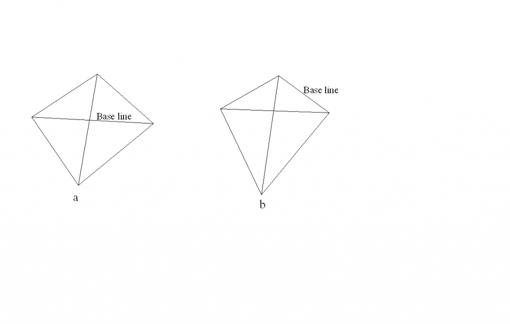
Hình 2.1. Mạng lưới gốc.
Đồ hình thiết kế đơn giản được thảo luận ở trên là vô cùng hữu ích khi mà không có các thiết bị đo chiều dài điện tử và sự giúp đỡ của máy tính, bởi trị đo chiều dài và tính toán có thể được hạn chế ở mứ thấp nhất. Tuy nhiên, khi thiết bị đo chiều dài điện tử được sử dụng thì nhiều khoảng cách có thể được đo và việc bố trí đồ hình khống chế sẽ không bị hạn chế ở dạng tứ giác trắc địa và đa giác trung tâm. Trên thực tế, ta có thể chỉ đo chiều dài, bằng cách ấy, tạo ra một lưới tam giác đo cạnh.
Phần lớn sơ đồ khống chế hiện đại bao gồm cả đo góc và đo có chọn lọc, hay tất cả, các cạnh và như vậy không nên gọi một cách đơn giản là lưới tam giác đo cạnh, nhưng theo quy ước, tên lưới tam giác nhìn chung vẫn được chấp nhận.
2.3. CHOICE OF STATIONS:
1. Từ mới:
Cover: [‘kʌvə]: n: vỏ, vỏ bọc / v: che phủ, bao bọc
Suitable: [‘su:təbl]: adj: (suitable for / to something / somebody) phù hợp; thích hợp
Exist: [ig’zist]: v: (to exist in / on something) là có thật hoặc thực sự; đã sống; tồn tại
Contour: [‘kɔntuə]: n: đường đồng mức
Visualize: [‘vi∫uəlaiz]: v
Cách viết khác : visualise [‘vi∫uəlaiz]: hình dung, mường tượng (vật không thấy trước mắt)
Consideration: [kən,sidə’rei∫n]: n: sự cân nhắc, sự suy xét
Summarize: [‘sʌməraiz]: v
Cách viết khác : summarise [‘sʌməraiz]: tóm tắt; tổng kết
Visible: [‘vizəbl]: adj: hữu hình, thấy được, có thể nhìn thấy, có thể thấy; trong tầm mắt
Ray: [rei]: n: tia
Obstacle: [‘ɒbstəkl]: n: sự cản trở, sự trở ngại, chướng ngại vật; vật trở ngại
Refract: [ri’frækt]: v: (vật lý) khúc xạ(ánh sáng), hiện tượng chiết quang.
Due: [dju:]: n: quyền được hưởng; cái được hưởng
Equilateral: [,i:kwi’lætərəl]: adj: (nói về hình) có các cạnh bằng nhau / đều nhau
Sufficient:: [sə’fi∫nt]: adj: (sufficient for somebody / something) đủ
Observation: [,ɑbzə’vei∫n]: n: sự quan sát, sự theo dõi
Provide: [prə’vaid]: v: (to provide somebody with something; to provide something for somebody) cung cấp; cung ứng
Configuration: [kən,figju’rei∫n]: n: hình thể, hình dạng
Compatible: [kəm’pætəbl]: adj: hợp nhau, tương hợp
Distinct: [dis’tiηkt]: adj: riêng, riêng biệt; khác biệt
Bisection: [bai’sek∫n]: n: sự chia đôi, sự cắt đôi
Theodolite: [θi’ɔdəlait]: n: máy kinh vĩ
2. Bài đọc:
The area to be covered by a triangulation scheme must be carefully reconnoitred to select the most suitable positions for the control stations. Existing maps, especially if contoured, can be of great value since the size and shape of the triangles formed by the stations can be difficult to visualize in the field.
When planning the scheme, certain considerations should be kept in mind, which may be summarized as follows:
a, Every station should be visible from the adjacent stations. Rays passing close to either the ground or to an obstacle should be avoided since they can be refracted due to air temperature diffirences.
b, The triangles formed thereby should be well-conditioned, that it to say, as nearly equilateral as possible. No angles should be less than 300, if at all possible. That scheme should be kept as simple as possible, but with sufficient redundant observations to provide the necessary checks and to increase precision.
c, The size of the triangles will depend on the configuration of the land, but they should normally be as large as possible compatible with the distinct bisection of signals, having regard to the type of the theodolite used.
3. Dịch:
Khu vực được bao phủ bởi đồ hình lưới tam giác cần phải được khảo sát một cách cẩn thận để chọn được những vị trí thích hợp nhất cho các trạm khống chế. Từ bản đồ có sẵn, đặc biệt là đường đồng mức, có thể có giá trị lớn do kích thước và hình dạng của tam giác được tạo bởi các trạm máy khó có thể nhìn thấy ngoài thực địa.
Khi bố trí đồ hình, chắc chắn là những vấn đề cần phải được quan tâm mà có thể được tổng kết như sau:
a, Mọi trạm máy nên được thông hướng với các trạm liền kề. Các tia ngắm không quá gần mặt đất hay qua chướng ngại vật bởi chúng có thể bị ảnh hưởng bởi chiết quang do nhiệt độ không khí khác nhau.
b, Hình thức của tam giác do đó nên được thành lập với điều kiện phù hợp, có nghĩa là, các cạnh gần như đều nhau đến mức có thể. Các góc không nên nhỏ hơn 300, nếu tất cả có thể. Đồ hình nên đơn giản, nhưng cần cung cấp trị đo thừa cho việc kiểm tra điều kiện và để tăng độ chính xác.
c, Độ lớn của tam giác sẽ được quyết định dựa vào hình dạng của khu vực đo, tuy nhiên, chúng nên càng lớn ở mức độ có thể càng tốt, tương ứng với tiêu ngắm của máy kinh vĩ, liên quan đến loại máy kinh vĩ mà ta sử dụng.
EXERCISE:
1. Where is triangulation employed?
Triangulation is employed extensively as a means of control for topographic and similar surveys.
2. What does a triangulation system consist of?
A triangulation system consists of a series of triangles in which one or more sides of each triangle are also sides of adjacent triangles.
3. What do the lines of a triangulation system form?
The lines of a triangulation system form a network tying together the points or stations at which the angles are measurement.
4. Where are the triangulation stations located?
The vertices of the triangles are the triangulation stations.
5. What is avoided by the use of the triangulation method?
By the use of the triangulation method, the necessity of measuring the length of every line is avoided.
6. Why should the lengths of the two or more lines in each system be measured?
Because unavoidable errors in the field measurement, so the lengths of the two or more lines in each system should be measured as a means of checking the computed distances.
7. How are the lines whose lengths are measured called?
The lines whose lengths are measured are called based lines.
8. What is known in geometrical figure offorded by the arrangement of the triangles?
The theoretical value of the sum of included angles is known.
9. What should the lengths of the sides in any triangle be proportional to?
The lengths of the sides in any triangle should be proprotional to the sines of the angles opposite.
10. Why is it not necessary to measure every angle in a triangulation system?
Because the third can be readily computed.
11. Why are all the angles measured?
Because measure all angles permit the application of the known conditions as a measure of the precision of the measurements, or as a means of adjusting the errors.
12. When planning the scheme, what should one keep in mind?
When planning the scheme, certain considerations should be kept in mind, which may be summarized as follows:
a, Every stations should be visible from the adjacent stations. Rays passing close to either the ground or to an obstacle should be avoided since they can be refracted due to air temperature diffirence.
b, The triangles formed thereby should be well-conditioned, that it to say, as nearly equilateral as possible. No angles should be less than 300, if at all possible. That scheme should be kept as simple as possible, but with sufficient redundant observations to provide the necessary checks and to increase precision.
c, The size of the triangles will depend on the configuration of the land, but they should normally be as large as possible compatible with the distinct bisection of signals, having regard to the type of the theodolite used.

